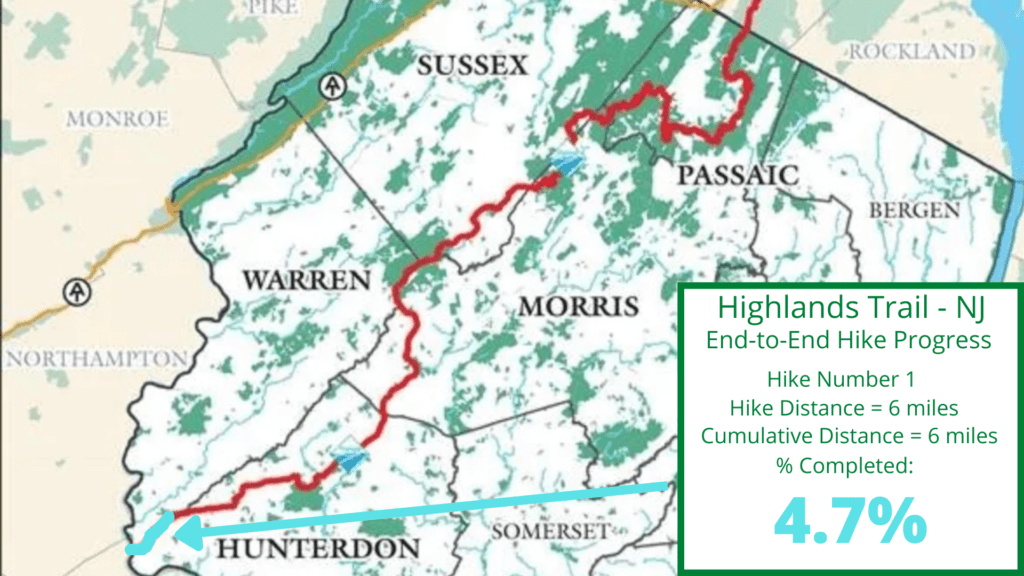
NJ Highlands Trail – Hike 1 is the first section of the Highlands Trail in New Jersey. This hike begins on the Riegelsville Bridge over the Delaware River on the Pennsylvania-New Jersey border and ends at the Dennis Rd. parking area at the Musconetcong Gorge Preserve. The Highlands Trail runs through parts of NJ and NY, from the Delaware River to the Hudson River. Ths trail covers about 170 miles, with over 120 miles in New Jersey. Camping on the trail is prohibited, so day-hiking is the only way to complete the entire Highlands Trail. Below, you will find key facts and details about the NJ Highlands Trail Hike 1.
Key Facts: NJ Highlands Trail – Hike 1
Mileage and time
6.07 miles from the middle of the Delaware River (on the Riegelsville Bridge) to the Dennis Rd. parking area at the Musconetcong Gorge Preserve. This hike lasted 2 hours and 13 minutes, including a few breaks and a surprise “swim” (21:52 pace per mile).
Rating
The first four miles of this hike are on roads, so I will rate those as easy even though there were a few uphill sections. The last two miles are in the Musconetcong Gorge Preserve and are easy to moderate. This last section has some rocky areas, a few manageable uphills, and a creek crossing.
Notable trail sections
The Riegelsville Bridge is an interesting starting point with nice views of the Delaware River, and the Musonetcong Gorge Preserve is always a great place to hike. You will walk past the Musconetcong River Wildlife Management Area, but the trail has not been relocated through this preserved area.
Road walking
Yes, yes, and yes. This section of the Highlands Trail is 2/3’s road walking and 1/3 on trails. The good news is that the roads are rural and scenic. After 4 miles, though, I wanted to celebrate when dirt was under my shoes.
Do I like road walking? Not really, but you just have to make the best of it and enjoy the scenery. I remind myself that it takes decades for long-distance trails to move completely off roads. We all benefit from the long-term planning of folks that manage trails. If you want to support the Highlands Trail maintainers, consider joining the NY/NJ Trail Conference by visiting their website.
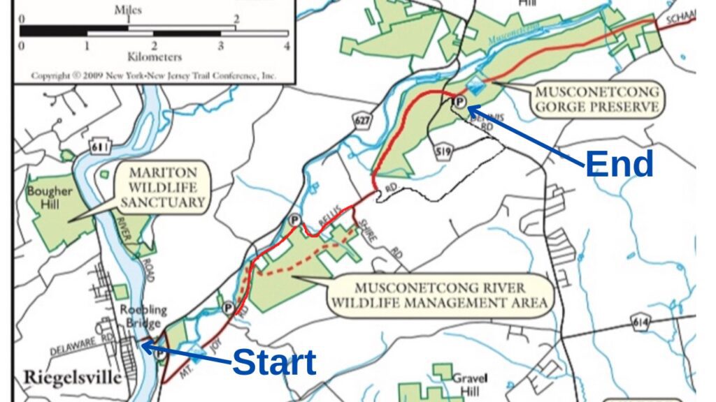
NJ Highlands Trail – Hike 1 Trail Map
Family Friendly
You may want to avoid the road sections if hiking with small children. I would park at Dennis Rd. with children and do an out-and-back section of the Highlands Trail or even the Musconetcong Gorge Loop hike.
Parking areas
I was dropped off near the Riegelsville Bridge, and we left my car at the Dennis Rd. parking area at the Musconetcong Gorge Preserve. Parking areas can be found at the following locations: near the Riegelsville Bridge, on Mt. Joy Rd., on Cyphers Rd. (not shown on map) just off of Bellis Rd., and on Dennis Rd.
Trail Tips
- On the 4-mile road walk section, trail signs are spaced out, but keep walking on the road until you see two blazes with one offset for a turn. The blazes always indicated when turns occurred.
- No matter what side of the street the trail blazes are on, always walk on the left of the road so you can see vehicles coming at you.
- When the trail leaves Bellis Rd. to enter the Musconetcong Gorge Preserve, just follow the trail around the edge of the field until it enters the woods. The trail was hard to spot early in the season, but you will see signs before too long.
- When crossing Rt. 519 on the final mile of this hike, just follow the signs. Step over the guard rail, look both ways, and walk up the grass towards the teal blaze into the woods.
- The dotted line on the map is the proposed section through the Musconetcong River Wildlife Management Area. The trail has not been relocated off the road yet.
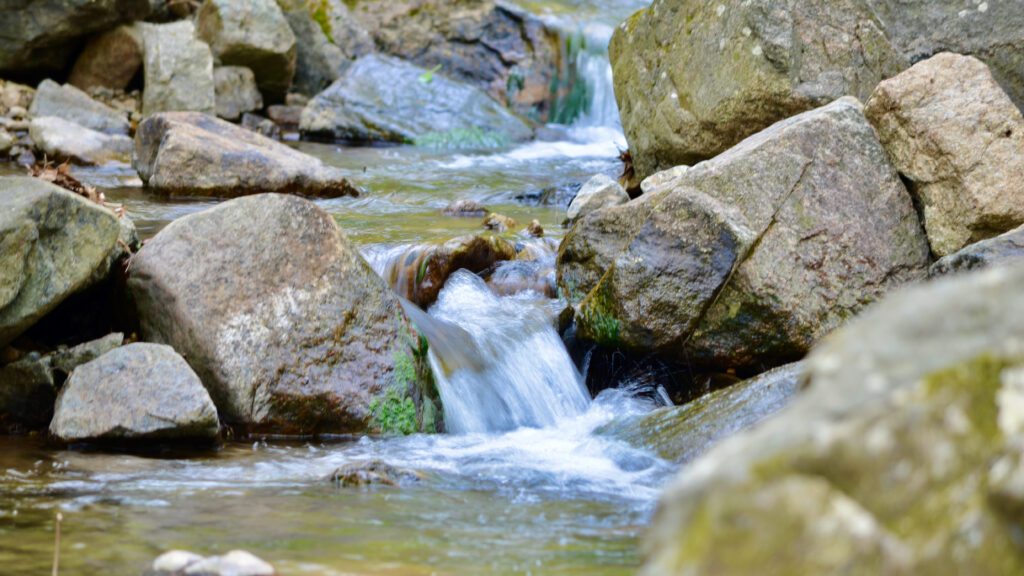
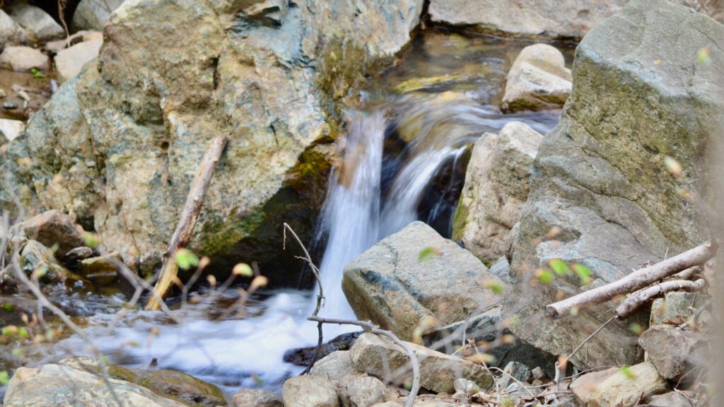
- Remember, rocks are slippery in creek crossings! I slipped on a rock in a creek and found out how cold the water was. See a short video of my failed creek crossing below:
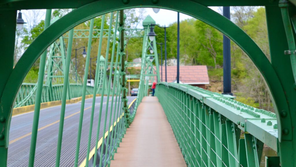
Begin at the Riegelsville Bridge for NJ Highlands Trail – Hike 1
Almost everyone knows that the Appalachian Trail runs from Georgia to Maine. But many people in the NY/NJ area have no idea where the Highlands Trail begins. The guy in red (see picture below) didn’t know he was standing near the starting point for the Highlands Trail. As a matter of fact, we talked for about ten minutes and I told him the route of the trail and he seemed fascinated.
I parked my car at the Dennis Rd. parking area in the Musconetcong Gorge Preserve and my wife dropped me off at a parking lot just before the Riegelsville Bridge on the NJ side of the Delaware River. I walked to Pennsylvania and then turned around and started my hike.
After walking off the bridge into NJ, you make a right on River Rd, left on 627, and then another right on River Rd. At this point, you have about 3.75 of road walking to go.
NJ Highlands Trail – Hike 1: Road Walking
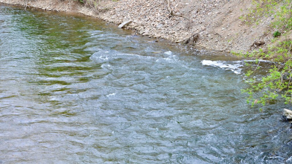
The first noticeable point of interest is walking over the Musconetcong River just above where the river joins the Delaware River. The Musconetcong is a beautiful river that is known for its trout fishing. I noticed a handful of folks fishing from under the bridge that I walked over.
Eventually, the trail makes a left on Mt. Joy Rd. and starts a very reasonable uphill section through a rural, residential area. All of the people that I saw waved and seemed used to having hikers pass by.
The trail follows Mt. Joy Rd. for a while until it turns left to go over the Musconetcong River on the Finesville Bridge. The trail proceeds straight on Bellis Rd., but I walked over t0 the bridge and took a break on a rock wall overlooking the river.
The Finesville Dam
If you looked to the right you will barely notice what remains of the Finesville Dam. Actually, if not for the sign, most would think it’s just some rocks and small rapids. According to the sign, the first dam was built in 1751 at this spot. The river at this spot fueled local industry until around 1990. That is one productive river!
After industrial use at this spot stopped, momentum began to restore the river by removing dams. This returns the waterway to its natural state and allows native fish to migrate upstream. This dam was removed in 2011. The Musconetcong Watershed Association helps manage the protection and preservation of the river and its watershed. Visit the MWA website for more information or to join.
Musconetcong River Wildlife Management Area
A hiker (or walker at this point) will see a sign for the Musconetcong River Wildlife Management Area. Eventually, the trail will be relocated off the road and into the woods in this area. For now, you will see some nice views of the river on your left. You can even take a couple of fishing access trails as I did to get up close to the Musconetcong River.
Keep walking and you will find the trail (or road) going uphill. Soon your feet will hit the dirt.
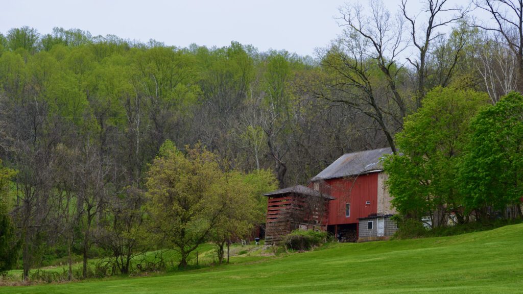
Musconetcong Gorge Preserve
NJ Highlands Trail – Hike 1 leaves the road near a farm field (see picture below). The trail was hard to make out but follow the sign and hug the outside of the field for just a little while. You will soon notice that the trail turns into the woods and walking now turns to hiking!
The Musconetcong Gorge Preserve is a beautiful place to hike. If you want to avoid the road sections or have kids, just park at Dennis Rd. and enjoy all of the trails that this area offers. For me, it was my first time on this southwest section of the Preserver and the Highlands Trail.
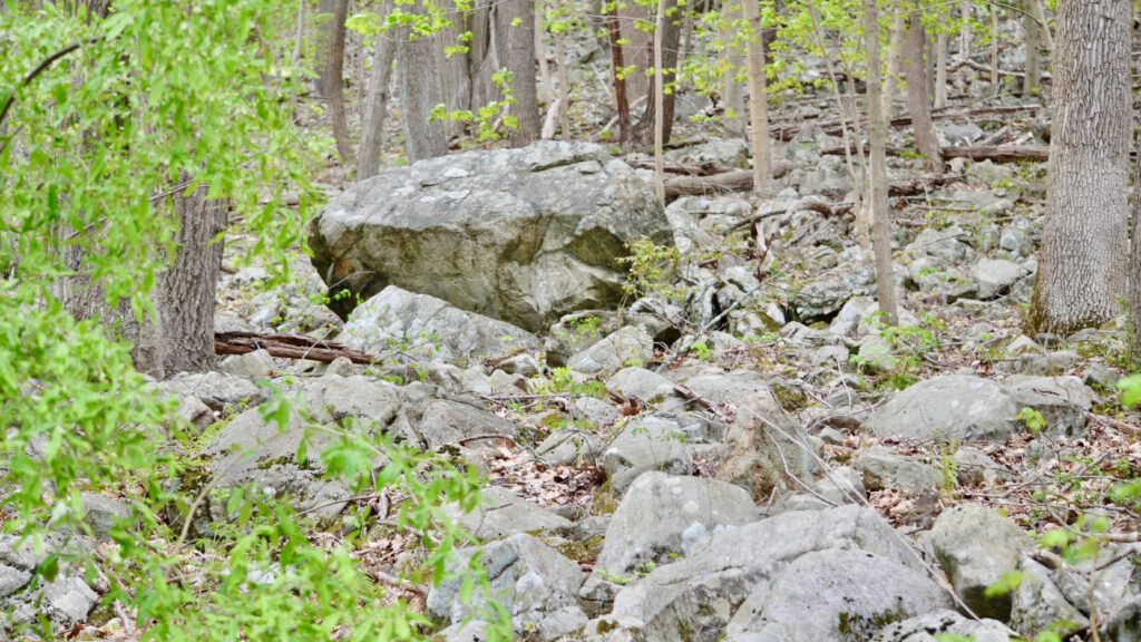
The trail was mostly easy to navigate and blazed well. I saw blooming dogwoods in the forest, boulders, and nice views to the left as the trees are still mostly without leaves. I enjoyed a small stream crossing, despite falling in!
After a nice walk in the woods, the trails crossed Rt. 519. Just follow the trail signs, step over the guard rail, look both ways, and head into the woods on the trail once over the road. Rt. 519 looks like a major road, but only one car passed while I was there.
The last section of the trail proceeds uphill within a beautiful forest. You will come to an intersection with a blue-blazed trail, which is the Musconetcong Gorge Loop Trail. Just stay on the Highlands Trail to the right and you will soon arrive at the Dennis Rd. parking area.
The significance of the first section of a hike
Hiking the entire Highlands Trail, or hiking a longer section in the area where you live, is a worthy objective. Just starting and chipping away at the goal is progress and it feels good to experience a section of the trail that you have never seen before.
Hiking the Highlands Trail is a fantastic way to see a region of New Jersey that many enjoy. Forests, streams, rivers, and wildlife are all waiting for you to experience. You just have to take the first step…and in this case the first section. Do your research, make your plans, and hit the trail so that someday you, and I, may be able to say that we hike the entire Highlands Trail.
Happy Trails!
Please visit the NY/NJ Trail Conference website for more information about the NJ Highlands Trail – Hike 3.
A video of this hike (NJ Highlands Trail – Hike 1)
This video summarizes the sights and terrain of NJ Highlands Trail – Hike 3 and includes footage of Jugtown Mountain Preserve, Tower Hill Reserve, Spruce Run Recreation Area, and the Union Furnace Nature Preserve.
Click here to see Highlands Trail NJ – Hike 2: the next section hike on the Highlands Trail.
Highlands Trail NJ End-to-End Progress: